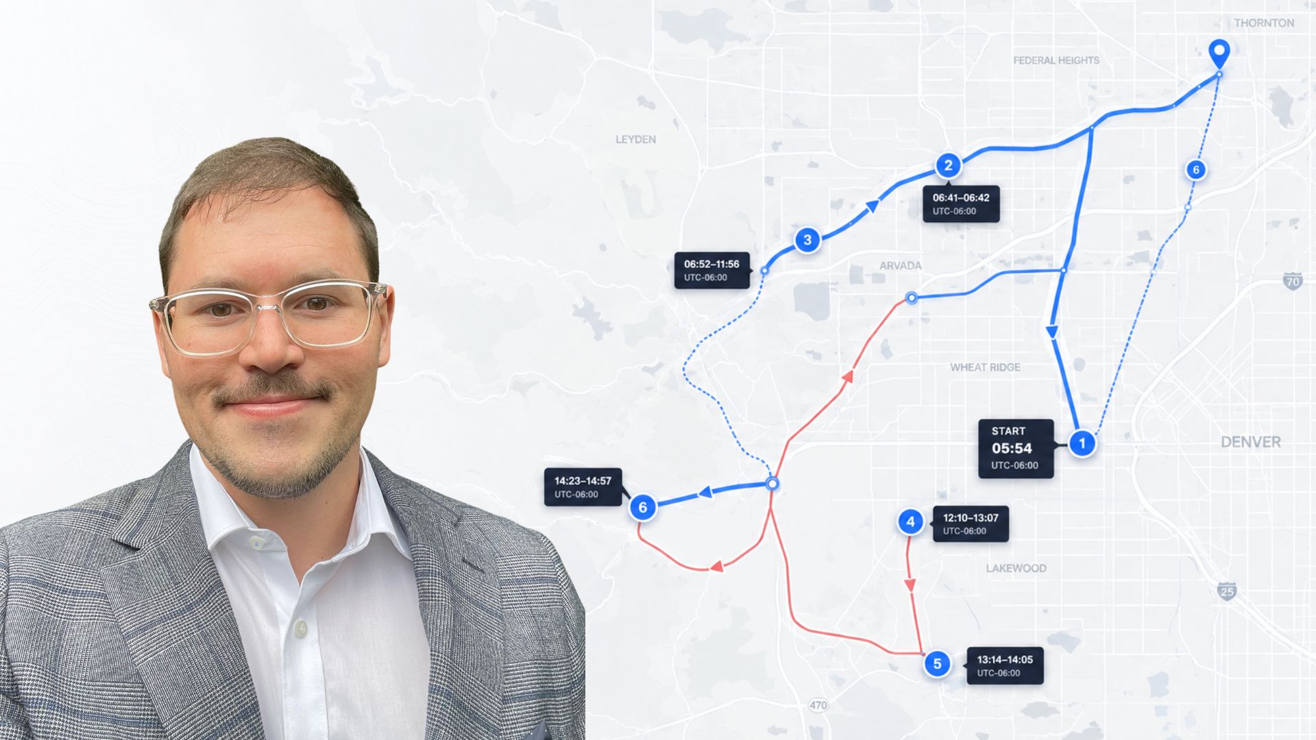
Jason Lesser is the founder of Map and Track, a digital forensics platform that helps investigators analyse and present location data from mobile devices. In this interview with Forensic Focus, Jason discusses the growing importance of location evidence and how movement patterns can support investigations.
Tell us about yourself and your background.
I never set out to work in digital forensics. My career in digital forensics began as a software developer creating practical forensic tools to help investigators solve problems that existing software could not adequately address.
Over the past 15 years, I have worked across both the private sector and law enforcement, and that mix of software development and digital forensics has shaped the way I approach problems and ultimately led me to create Map and Track.
What inspired you to create Map and Track?
The idea came from repeatedly seeing the same challenge during examinations.
When reviewing location evidence, a lot of attention is understandably placed on individual records. Questions such as where the data originated from, how it was recorded, and how accurate it may be are all important considerations.
However, I found myself becoming increasingly interested in the broader context. Rather than looking at a single coordinate in isolation, I wanted to understand how a device moved over time, how long it remained at locations, how frequently it returned, and whether those movements aligned with other information available in an investigation.
In many cases, understanding the movement pattern of a device can provide valuable investigative context that may not be immediately obvious when viewing individual records alone.
Why do you believe location evidence is becoming more important?
Modern smartphones are becoming increasingly reliant on location information.
Location services now support navigation, weather forecasting, fitness tracking, photo organisation, recommendations, geofencing, predictive assistance, and many of the intelligent features users have come to expect from their devices.
As a result, devices are generating and retaining more location-related information than ever before. Depending on the device, operating system, applications installed, and user behaviour, investigators may recover location information from a variety of different sources.
What makes this particularly valuable is that these records can often be analysed collectively to provide insight into movement patterns, routines, significant locations, and behaviours over time.
As mobile devices continue to evolve and become increasingly dependent on contextual awareness, I believe location-related evidence will continue to play an increasingly important role in digital investigations.
What challenges do investigators face when working with location data?
One of the biggest challenges is volume.
A modern mobile device can potentially contain thousands of location-related records originating from different sources. Each source may provide a different level of accuracy, retention period, and context.
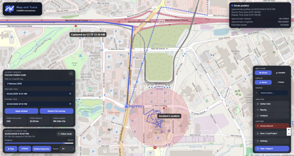
Another challenge is presentation. Location data is often displayed as lists of coordinates and timestamps. While this information is essential from a forensic perspective, it can sometimes make it difficult to quickly understand what the data is actually showing.
Investigators are often trying to answer practical questions such as:
- Where did the device travel?
- How long did it remain there?
- Did it return to the location?
- Are there patterns of movement?
- Do those movements align with other evidence?
Answering those questions efficiently can require significant manual analysis.
What makes Map and Track different from traditional mapping tools?
Map and Track was designed specifically around investigative workflows.
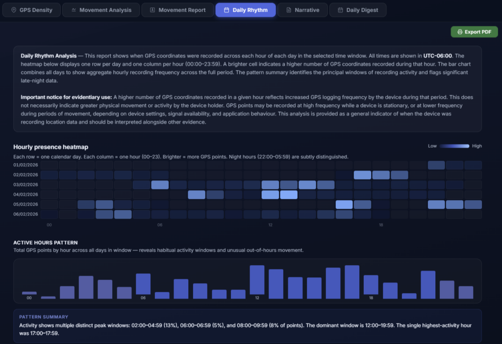
The platform focuses on helping users visualise movements, identify significant locations, understand timelines, calculate dwell times, and analyse behavioural patterns.
One area I felt was particularly important was reducing the amount of manual work required to understand location data. Rather than requiring investigators to manually calculate time spent at locations or identify recurring visits, the platform is designed to surface that information quickly and visually.
The goal is not simply to display points on a map, but to help investigators better understand the context surrounding those points.
How do you see location evidence being used alongside other forms of evidence?
Location evidence is rarely considered in isolation.
In many investigations, it forms one part of a much broader evidentiary picture. What makes location data particularly useful is its ability to provide context and direction for further enquiries.
For example, movement data may assist investigators in identifying relevant CCTV opportunities, understanding timelines, comparing witness accounts, examining communication activity, or assessing other digital evidence recovered during an examination.
When considered alongside other investigative information, location evidence can help build a clearer understanding of events and support more informed investigative decisions.
What trends are you seeing in mobile device location data?
The biggest trend is the increasing amount of information being generated by devices.
As operating systems and applications become more intelligent, they are relying more heavily on location information to provide personalised and context-aware experiences.
We are seeing devices record location-related information from a growing number of sources, often creating datasets that can provide valuable insight into a device’s movements over time.
At the same time, expectations around data analysis are changing. Investigators are increasingly looking for tools that can help them quickly understand large datasets and identify meaningful patterns without spending hours manually reviewing records.
What has been the most rewarding part of developing Map and Track?
The most rewarding part has been seeing investigators look at location evidence differently.
Many people are familiar with viewing coordinates on a map, but when they begin exploring movement patterns, timelines, repeat visits, and dwell times, they often start asking new questions and identifying investigative opportunities they had not previously considered.
Seeing those moments where someone gains a new perspective on the data has been incredibly rewarding.
What advice would you give to digital forensic practitioners who want to improve their understanding of location evidence?
My advice would be to spend time exploring the context surrounding location records rather than focusing solely on the individual artefacts themselves.
Understanding where a record originated from and how it was recorded is important, but it is equally important to consider how that information relates to other records and what it may reveal about the broader movements and activities of the device.
Location evidence can provide valuable insight when analysed thoughtfully and in conjunction with other evidence sources.
As with all digital evidence, understanding both the strengths and limitations of the data is essential.
What do you hope people take away from Map and Track?
I hope it encourages investigators and digital forensic practitioners to explore the potential of location evidence more deeply.
Modern devices are generating an increasing amount of location-related information, and that information can often provide valuable context during an investigation.
My goal with Map and Track has always been to make location analysis more accessible, more intuitive, and easier to understand. If the platform helps investigators identify new leads, better understand device movements, or communicate their findings more effectively, then it has achieved exactly what it was designed to do.
“A coordinate tells you where a device was. A journey tells you what it was doing.”
Map and Track is a location analysis platform for digital forensic investigations. It helps investigators turn extracted mobile device location data into visual timelines, movement analysis, key location insights, and clear reports. Designed to support investigative workflows, Map and Track enables users to review journeys, identify dwell times and repeat visits, and present location evidence in a more accessible and meaningful way.